Methodology
Our project assumes that a culturally meaningful biography of ancient Attica is both promising and timely. Until now, studies on Athenian settlement patterns have mostly focused on the Classical and later periods, mainly viewed from a literary perspective. Alternatively, recent studies have discussed precedent periods, but they have presented a simplified cataloging of the archaeological sites.
The rich material from Attica nevertheless remains incomplete, fragmentary and dispersed in minor publications, not least because of a persistent 'great divide' in scholarship between the late Bronze Age and the Iron Age and later periods. The paradox is even more pronounced considering the importance of Attica in:
- (i) the conception of a distinctive material culture;
- (ii) its remarkably coordinated evolution that led to an outstandingly expanded regional city-state in Greece (2.550 square km circa, comparable only to Laconia);
- (iii) the political revolutions leading to new conceptions of citizenship and, finally, the birth of democracy (in which both social and spatial arrangements played a major role).
The aforementioned phenomena presuppose complex dynamics that are still to be unraveled. Consequently, the debate on settlement patterns in Attica is still open. Instead, our project starts from a new theoretical and a practical perspective. Overall, the wealth of spatial information, that GIS offers, would allow a thorough examination of the archaeological record and consequently a detailed mapping of social dynamics. Although we can only recover some of the factors which affect historic decisions about what to do where, and where to do what, the combination of GIS and of high quality archaeological data enables a much more subtle and sophisticated monitoring of social dynamics and the negotiation of regional and sub-region identities based on a complex network of political attachments.
We propose a study of settlement dynamics in Attica using GIS and theoretical-epistemological paradigms based on up-to-date social sciences, in synergy with quantitative, probabilistic, computational and statistical methods applied to the study of spatial data. Based on a stratigraphic reassessment of all archaeological data in the landscape in a diachronic perspective and on the strong anthropological-sociological perspective of the French archaeological tradition of the so-called "École de Paris", the research aims to a more accurate interpretation of the settlement history and, through this, the elucidation of social/political dynamics occurred in the region.
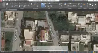
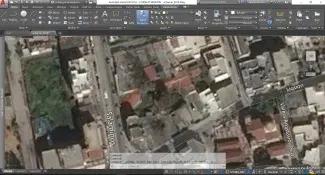
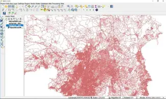
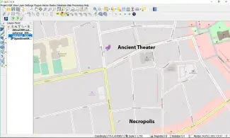
Τhe approach will be the study of regional identities as a result of interwoven relations of powers and specific interests, taking place in space and changing over time. Ultimately, this is linked to long genetic processes of smaller boosting identity units (urban centers, villages, kinship groups). Specific micro-regions (or ‘settlement chambers’ in the German geographical tradition) will be the core analytical unit for a detailed holistic discussion. These will coincide with the best surveyed among the administrative units or territorial communities (demes) of the Cleisthenian reform and main institution in function of the democratic regime excluding the five urban demes of Athens which necessitate a separate study. We focus instead on the study of the demoi, the face-to-face territorial communities, micro-cosmos of the city-state where trough participation in rituals, politics, and public life, apprenticeship to citizenship was taken place. The local communities of the Athenian were so the true “basis” of the democratic regime. The research will individuate and evaluate patterns of change, transformations, continuities and/or discrepancies in the settled space in a diachronic perspective. The salient physical environmental features, data from excavations, surface surveys, topographical studies, will be critically revisited, and geo-referenced in Adobe Autocad environment in order to obtain distribution maps of human occupation, clustered through assessment of their chronology, rank, size, multi-symbolical and social functions. Textual and epigraphic sources will have an important part to play. They are, essentially, cognitive spatial constructions and again space-generating mediators (a boundary inscribed stone is a case in point). As such, they are thus location-able and question-able as units of spatially meaningful entities. The systematic collection of all available archaeological, historical and geographical data will ultimately be embedded as metadata in a relational database in a GIS platform.
The GIS will incorporate the raw data as categorized in multi-functional and multi-semantical entities. Raw data will be re-aggregated as components of social units put in place (events) in order to query their multi-semantic and variable functions according to context and cognition. As context we mean the location-able negotiation of emplacements and enactments of social praxis unfolded in and linked to different social units. As cognition we intend that of the observer (ancient persona or, indeed, the modern scholar) which is of course entirely subjective and retrievable only by approximation. Based on this structure, GIS would permit multidimensional analysis of spatial correlations between different social (inter-) actions. Social interaction can be captured as a flow of information among social agents linked by a network of spatial dependencies. The link between settlement patterns and social interactions is given through the analytical deconstruction of the archaeological record and its reconstruction as a meaningful topo-poetic entity. The cross-talk between such entities (hubs) creates a grid or network of nodes where cognition and empirical facts (or social interactions) take place, becoming thus measurable for interpretation. Consequently, GIS is the ideal tool for the study of such networks as long as the mapping obtained is not a merely geographical instrument but a representation of lived (absolute, relative and relational in David Harvey's terms) experience of places (topoi) that "happen".
Computational probabilistic statistics will be applied to obtain an assessment of spatial-temporal uncertainties of the archaeological context and thus produce flexible interpretative trajectories of cultural phenomena. Eventually, the deliveries will be written down as a cultural history.
References
Demoi in the classical age: J.S. TRAILL, The Political Organisation of Attica: a study of the demes, trittyes, and phylai, and their representation in the Athenian council, Princeton, 1975; R. OSBORNE, Demos. The discovery of Classical Attika, Cambridge 1985; D. WHITEHEAD, The Demes of Attica, 508/7-250 B.C., A Political and Social Study, New Jersey, 1986. Settlements in Attika (Iron Age-Classical Age): A. MERSCH, Studien zur Siedlungsgeschichte Attikas von 950 bis 400 v. Chr., Frankfurt, 1996. Settlements in Attika (Bronze Age): S. PRIVITERA, Principi, pelasgi e pescatori. L'Attica nella tarda età del bronzo, Paestum, 2013. Landscape, GIS and mathematics in archaeology: M. C. CAPANNA & P. CARAFA, 'Il progetto “Archeologia del suburbio di Roma” per la ricostruzione dei paesaggi agrari antichi', in V. Jolivet (ed), Suburbium II. Il suburbio di Roma dalla fine dell’eta’ monarchica alla nascita del sistema delle ville, V-II a.C., Rome, 2009, p. 28-29; M.C. CAPANNA, P. CARAFA, 'I paesaggi rurali tra il Suburbio di Roma e il Latium Vetus', in P.J. Attema & A.L. Fischetti (eds.), Tra Appia e Latina: dinamiche insediative e sviluppo del territorio alle pendici dei Colli Albani, Groningen Archaeological Series (GAS), forthcoming; B. DAVID & J. THOMAS (eds), Handbook of Landscape Archaeology, Walnut Creek, 2008; A. BEVAN & M. LAKE (eds), Computational Approaches to Archaeological Space, Walnut Creek, 2013; F. GILIGNY et al. (eds) 2015, 21st Century Archaeology. Concepts, methods and tools. Proceedings of the 42nd Annual Conference on Computer Applications and Quantitative Methods in Archaeology, Oxford, 2015. Settlement chambers: J. BINTLIFF, 'Catchments, Settlement chambers and demography: case studies and general theory in the Greek landscape from prehistory to early modern times', in F. Favort & L. Nununger (eds), 7 Millenia of Territorial Dynamics. Settlement pattern, production and trade from Neolithic to Middle Ages, Dijon, 2009, p. 107-117. Athens: E. GRECO et al., Topografia di Atene, Sviluppo urbano e monumenti dale origini al III sec. d.C., I-V, Athens-Paestum, 2010-2015. Demoi, basis of democracy: R. J. HOPPER, The basis of the Athenian democracy. Inaugural lecture delivered in Shettfield University, 1957. Place as event: E. S. CASEY, 'How to Get from Space to Place in a Fairly Short Stretch of Time: Phenomenological Prolegomena', in S. Feld & K Basso (eds), Senses of Place, 1997. Archaeology as Cultural History: I. MORRIS, Archaeology as cultural History, Oxford, 2000.